


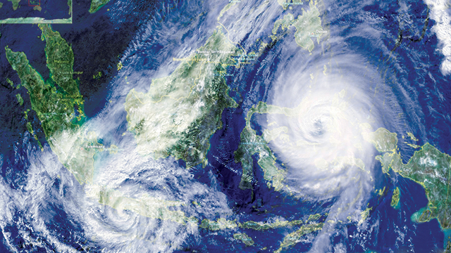
Jakarta (Greeners) – Meteorology, Climatology, and Geophysics Agency or locally known as BMKG states that recent wind rains occurs because of cyclonic pattern forming cyclone wind or tropical cyclone. The agency’s analysis shows maximum wind speed at the center of the cyclone reaches to 40 knots or 75 kilometers per hours.
Deputy of Meteorology, Mulyono R. Prabowo, said that cyclone was initially detected developing on 12 December 2018, in Indian Oceans, which transformed as tropical cyclone on Saturday, 15 December, located at 1400 kilometers from Bengkulu, southwest of Sumatra island.
The tropical cyclone, dubbed as KENANGA, is detected in the regions under Tropical Cyclone Warning Center, in Jakarta.
“Based on recent monitoring, this tropical cyclone tends to move southwest, leaving Indonesia areas, and predicted to be at 2,754 kilometers from Indonesia areas within 72 hours,” said Prabowo in a press release on Monday (17/12/2018). “This cyclone will bring indirect impacts, including wind speed increase in west part of Sumatra coastal areas and tide rises between 2.5 to 4.0 meters in Mentawai Islands and Sunda Strait.”
READ ALSO: BMKG Warns Extreme Weather Affected by Climate Change
Furthermore, he said that wind speed increases mostly caused by the air mass flow from southern part of Central Indonesia. The increases are predicted to hit south of Java island, including Banten, DKI Jakarta, West Java, Central Java, DI Yogyakarta, East Java, Bali, NTB and NTT.
The air mass from the south, which dominates, tends to reduce rainfall in parts of Sumatra and Java islands and increases rain intensity in central and eastern Indonesia.
“The air mass circulation is controlled by West Wind dominating Indonesia regions. Meanwhile, other regions that are dominated by East Wind starts from southern Sumatra, Java, Bali and Nusa Tenggara,” he said.
Cyclonic pattern is formed in western Sumatran waters and western part of West Kalimantan. The air mass meets in waters of southern Kalimantan, Southeast Sulawesi, Maluku and northern Papua potentially forming rain clouds.
READ ALSO: BMKG and Health Agency To Release Dengue Fever Early Warning System for Jakarta
Furthermore, the agency predicts cold air flow from Asia will come to Indonesia and set up convergency areas along with triggers rainfall increases in western Indonesia.
The regions potentialy hit by heavy rains are West Sumatra, Bengkulu, Riau, Jambi, South Sumatra, Lampung, Bangka Belitung, Riau Islands, Banten, DKI Jakarta, West Java, DI Yogyakarta, East Java, West Kalimantan, and Central Kalimantan.
The agency warns people on hydrometeorology disasters, such as floods, flash floods, landslides and strong winds, especially for areas with high intensity rain in the next few days.
In addition, people living in coastal areas especially southern Sumatra island needs to be aware on potentials of high tide and strong wind.
Kadarsah, head of climate change analysis, said that based on the latest research, climate change is the cause of cyclone winds intensity increase.
Despite not the largest contributor of global warming, Indonesia also contributes to global climate causing weather anomaly leading to cyclone winds.
“Global warming has a role in cyclone disasters. The trademark of cyclones usually accompanied by heavy rains, strong winds and dynamic speed (swirling, changing directions),” said Kadarsah.
Reports by Dewi Purningsih